This page contains information on using the TomTom Navigator 3 route planning package on a Pocket PC.
For information on later versions, see our TomTom Navigator page

Navigator, from TomTom is
a full navigation product designed for use with a Pocket
PC handheld computer. It comes with the required bits to allow this
to be used in-car, or you can use the software when strolling around if
making use of a handheld CF card GPS unit,
or a Bluetooth GPS receiver.
Navigator is normally supplied as a bundle including a GPS receiver
terminated with a Pocket PC connector (IPAQ, Pocket
Loox plus others), an in-car mount, and the Pocket PC mapping software.
Considerably cheaper than a dedicated in-car unit, and just as powerful,
this is a superb solution. This is a neat solution for those with an existing
Pocket PC. If you already have a GPS receiver and a Pocket PC, you’ll
be pleased to know that you can buy the software only, for around £120.
Features
of TomTom Navigator include:
- Fast and
reliable route planning on highly detailed, up-to-date maps - Automatic,
one-second recalculation when you move off the route - Automatic
positioning, zooming, and guidance by GPS - Guidance
by means of clear and timely verbal instructions, symbolic arrows,
and maps - Extensive
lists of useful or interesting locations - Destination
selection by means of: Favourites, Point of Interest, Clicking on
map, Entering address - Realtime
travel information via a GPRS mobile (Navigator v3)
The software
runs on a wide range of Pocket PC and Windows Mobile 2003 devices, including:
Compaq IPAQ 36xx, 37xx, 28xx, 39xx, 5400, iPAQ H5555 , iPAQ H6340 ,
iPAQ Hx4700 , iPAQ Rx3715, the Hewlett Packard Jordana 500, Casio Cassiopeia
E-115, EM-125 and EM-500, the o2 XDA and
XDA II range, Toshiba E330, E740, E750 & E800, the Fujitsu
Siemens Pocket Loox 600/610,
Packard Bell Pocket Gear 2030 / 2060 and the Dell Axim range. For the full
list of supported devices, see the TomTom site
Buying TomTom Navigator
Looking to buy TomTom Navigator or accessories? We recommend:
|
Using TomTom Navigator
Here’s a summary
of the hardware we’re using: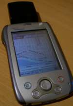
- Handheld Pocket
PC PDA – We use a Fujitsu Siemens Pocket Loox 600. Of key importance when choosing this machine, was the fact that the Loox has a CF
card slot. CompactFlash on a PDA is most commonly used to add extra
memory space, but can also be used to run CF modules, in this case,
our plug-in GPS receiver. If you’re looking for a cheap Pocket PC, it’s
well worth taking a look at the Dell
Axim X5. Although we have
no direct experience of this machine, at under £200 and with a
CF slot, this is a hot machine.
- GPS receiver – To work
out where you are on the planet, you need a receiver that can be pointed
at the open sky. Options open to us were a CompactFlash card receiver,
or a Bluetooth receiver. The CF solution was smaller, neater, and cheaper.
We’re using a CF GPS receiver that’s quite new, and it’s hard to get
hold of in the UK at the moment. We got our GlobalSat
BC-307 receiver in an eBay auction for under £100, but there are several around in the UK
for under £150. A card that had positive feedback from users is
the Pretec’s CompactGPS-LP, which has the added advantage of
coming with the CityMaps software, our current budget software of choice.
You’ll find this bundle at Amazon.
Using the software
Navigator is really designed to be used with live location data
from a GPS unit – although it can be used stand-alone for route planning
if required. If you’re not planning to use GPS, then consider the cheaper
TomTom
Citymaps application, which does a great job of getting you from A
to B at a fraction of the price, but lacks the bells and whistles we’ll
go on to discuss.
The Navigator software is supplied on a CD, and when you install
it, you install the core application, the GPS software, and you make a
choice about the type of map data to install. If you have enough free
memory on a CF or SD card, you can copy
the whole of the UK onto the card (95Meg), or you can select specific
regions in 16, 32 or 64Meg chunks. Software and maps are installed via
ActiveSync – a slow process with large maps (so speed up map installation,
you can use a memory card reader if you have one).
Navigator scores over TomTom CityMaps and Microsoft Pocket Streets,
in that it’s more than a simple mapping or route-planning tool – it’s
a fully interactive co-driver. You plan a route based on your current
position, obtained from the GPS receiver, and then
enter a destination. You can do this by pointing to a location on the
map, by entering the postal address (as well as street address, Navigator
support house numbers and UK postcodes) that you want to go to, by picking
a landmark or a saved location, or from the Pocket PC Contacts application
list view. This makes selection of an address incredibly easy although
searching for an address can be a little slow sometimes (not surprising
really… there’s a lot of streets in the UK, and to get a position for
any UK address down to within a few feet, demonstrates the power of this
application…)
You then have some choices – you can view a standard map (where if you’re
using GPS you can watch a moving dot superimposed onto the map showing
you exactly where you are) or can see detailed navigation instructions
in a list view. However, you’ll probably want to live in the ‘Navigator’
mode when you’re actually using the product on the move.
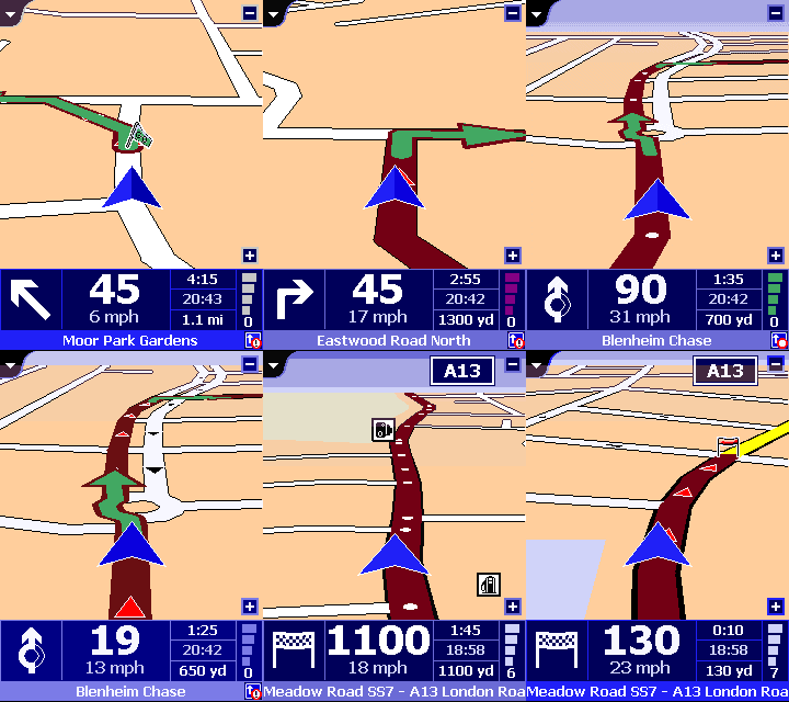
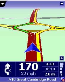
As soon as you select Navigation Mode, things change – and you get to
see a 3D view of where you are, which streets are near, and the direction
you need to go in. Set out on your journey, and prepare to be impressed.
As well as the clear route map, you get spoken voice prompts along the
way – normally about 10-20 seconds before a junction, and a repeat when
you get to the junction. The messages are pretty accurate, and in our
tests, very useful, with messages like "At the roundabout, take the
second exit", or "at the end of the road, turn left then turn
right". You also get warnings of which lane to be in, and when you’re
near your destination. Best of all, if you make a wrong turn, or know
a better way, the software re-plans the journey on the fly without any
need to touch the Pocket PC – and the planning is pretty intelligent (i.e.
doesn’t just tell you to turn around!). While you’re moving, the display
gives you distance to the next turn, your current speed, arrival time,
how long it’ll be before you reach the destination, the name of the next
road, details of the GPS signal you’re receiving, and icons to indicate
any overlays on the way.
The software really is an impressive piece of work – without sounding
too gushing (no, we’re not on TomTom’s payroll), this really is the killer
app for the Pocket PC (shame the software costs over £100 though).
The application is fully customisable, with a whole load of settings to
play with, such as a high-contrast night view (complete with stars on
the horizon!), different voices, road/area avoidance, a stack of overlays,
and warnings of London’s Congestion Charge areas.
 |
 |
Controlling the GPS
 The
The
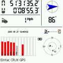
TomTom software installs a mini-app in the Pocket PC control panel, that
allows you to see information on the signal strength of the satellites
you’re receiving data from, a snazzy ‘log’ option that lets you record
a journey, and play it back later in real-time, and a display of your
long and lat positions, speed and direction (see the screenshot to the
right). This applet also controls the settings and ‘on / off’ for the
GPS connectivity.
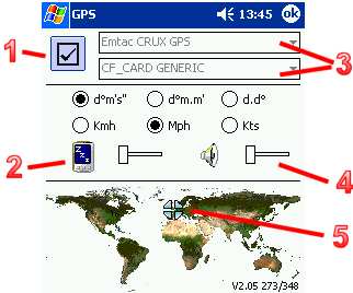
Below is a screenshot of this part of the application. (1) is the On/Off
box, (3) sets up which of the drivers to use… Navigator and CityMaps
come with a couple of dozen built-in, including the DeLorme Tripmate,
Destinator, Emtac CRUX and GPSJAQ, Garmin Etrex, Holux GM-200 and GM-210,
the NAVMAN GPS1000, GPS3000 and GPS100, the Pretec CompactGPS, StreetNav
iGPS, Rikaline GPS-6010, plus generic settings for NMEQ 0183 and SiRF,
as well as TomTom’s own range of receivers. CF, infrared, serial and Bluetooth
connectivity are all supported. (4) controls a couple of sound – for acquisition
and loss of signal, and (5) is a "you are here".
There are also settings for preferred speed format: kilometres-per-hour,
miles-per-hour or knots (kts), as well as the option to change the longitude
and latitude map co-ordinates display format: dº m’ s" (degrees,
minutes, seconds), dº m.m’ (degrees decimal minutes) and d.dº
(degrees and decimals).
We’re not quite sure what (2) actually does… something to do with keeping
the Pocket PC awake when Navigator is on (as opposed to turning off and
power saving), but it’s not clear, If anyone out there knows for sure,
please tell us!
Real-time Traffic information
 Version
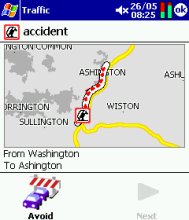
3 of TomTom Navigator saw the addition of a real-time travel information
service. In the UK, the travel data is supplied by ITIS.
Traffic information is downloaded to the Pocket PC via a mobile phone
with a GPRS data service. If your Pocket
PC has a built-in phone (e.g. the o2 XDA), you
already have a Pocket PC capable of using GPRS for Navigator. If not,
you may be able to connect your Pocket PC to a mobile phone using either
Bluetooth or Infrared.
The phone connects to the TomTom service over the Internet, and downloads
information about traffic problems straight into the Pocket PC, which
uses the information to update your route. There is a subscription charge
for using this service.
In practise, the service works rather well, although the quality of the
real-time traffic data sometimes lets it down.
For more on real-time
road information, see our Travel page
Speed
Cameras
 If
If
you’re using Navigator on the move, you might want to consider adding a
database of UK speed cameras. The best site we’ve come across is the PocketGPS
Safety Camera Database. The database that they provide is intended to be used with TomTom’s Navigator application. The
database gives longitude and latitude co-ordinates for the cameras, and
includes GATSO cameras, redlight cameras, and the locations of common mobile
speed camera locations.
The database has to be copied to the map folder on the Pocket PC, and then
you can add them to the map as an overlay (referred to as a POI – Point
of Interest). You’ll be able to see an icon of a speed camera in Navigator
view. Below are some instructions for installing and using the database.
Now comes the clever bit – get hold of a free application called CheckPOInt,
that can alert you audibly of an upcoming camera, by playing a WAV file
of your choice when you near a camera.
|
Installing the UK Camera Some basic instructions
In addition to the above…
Remember that you need to |
Frequently asked questions
- Application crash.
On a couple of occasions, we’ve hit application crashes, specifically
the following: "TomTom Navigator.exe has performed an illegal operation
and will be shut down. If the problem persists, contact the program
vendor. Program: TomTom Navigator.exe. Exception: 0xc0000005, Address:
000b2c6c". We got this using v2.24 (361). We’ve seen two solutions
proposed online:- This may be a problem with
custom POI files. Check the names used – the bitmap and the datafile
must have identical names: first one capital – rest lowercase. - One user solved the problem
by removing the optional colour schemes that were obtained from
the TomTom site. Removal solved the problem.
We found that reinstalling the
map (not the application), solved the problem. If you get a similar
crash, check the files in the map folder for anything odd. - This may be a problem with
Some useful links:
- Compact
Flash GPS – Information
on getting around with a Compact Flash GPS unit - See our GPS page for more on the global positioning system.
- PocketGPS
TomTom forum – Great forum for Navigator 2 and 3 chat. - See our Travel
page for information on mobile traffic and travel news. - Looking for GPS units, leads and adapter?
Try Expansys, Maplin,
or take a look on eBay.co.uk
Need help? Ask in our forum
|
Got a question, or need help? Ask in our forum
|

 Download
 Download